Photogrammetry offers museums, archaeologists, and heritage professionals a practical and non-invasive way to create accurate 3D digital records of artifacts, monuments, and sites. By turning ordinary photographs into precise, textured 3D models, this technology supports preservation, research, education, accessibility, and public engagement. This post explains what photogrammetry is, how the process works, and why it has become a valuable tool for cultural heritage work.
What Is Photogrammetry?
Photogrammetry is the technique of deriving reliable three-dimensional information about physical objects and environments from overlapping two-dimensional photographs. Software analyzes common points across multiple images taken from different angles to reconstruct geometry, scale, and surface details.
The method treats photographs as measurement data rather than simple visual records. It has evolved from traditional aerial surveying into a widely accessible tool for close-range applications in museums and heritage sites. Compared with laser scanning, photogrammetry often provides superior color and texture fidelity at lower equipment cost for many cultural objects.
How Photogrammetry Works: The Technical Process
The workflow follows a clear sequence from image capture to final model.
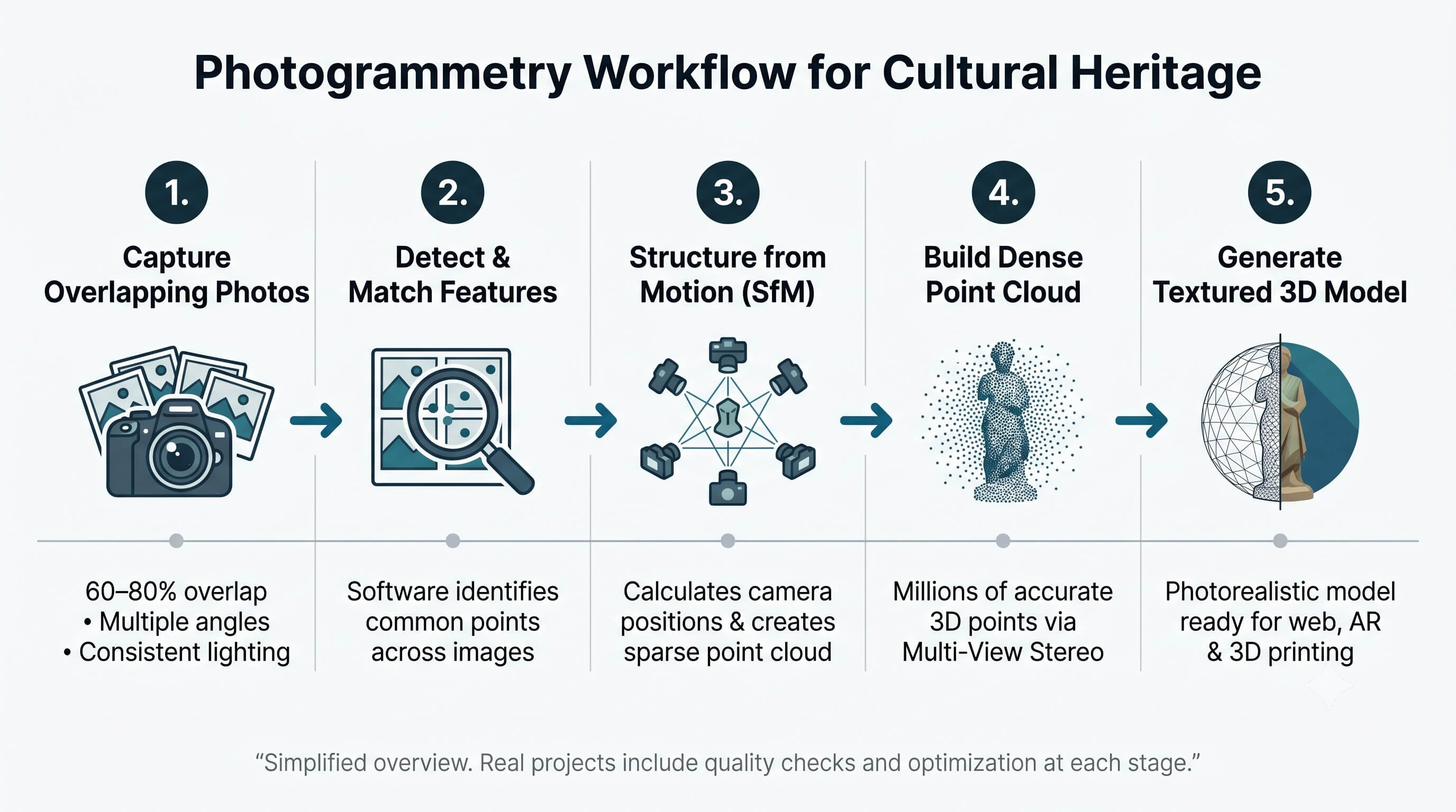
The full photogrammetry workflow: overlapping photographs processed through SfM and dense reconstruction into a final textured 3D model.
Image capture
High-quality results begin with careful photography. Capture dozens or hundreds of images with 60 to 80 percent overlap between shots. Maintain consistent lighting and cover the subject systematically from multiple angles. For small artifacts, a turntable or orbital path works well. For larger monuments or sites, combine ground-based photography with drone imagery when appropriate.
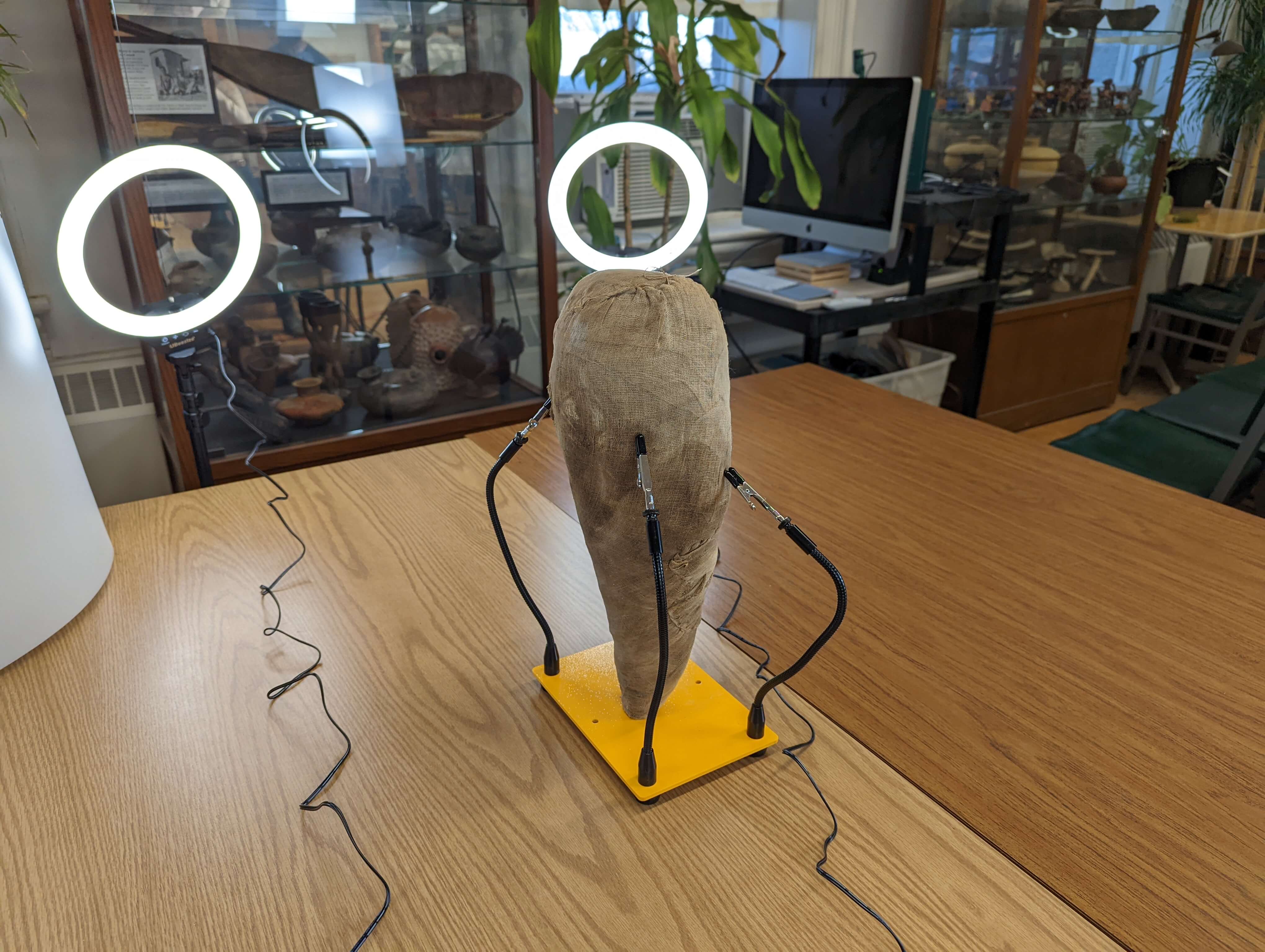
Controlled studio setup for artifact photogrammetry. Consistent lighting and systematic coverage are critical to a clean result.
Feature detection and matching
Specialized software identifies distinctive points visible across many images. These keypoints allow the program to understand relationships between different photographs.
Structure from Motion (SfM)
The software calculates the position and orientation of each camera while building a sparse point cloud of the scene. This step establishes the basic three-dimensional structure.
Dense reconstruction
Multi-View Stereo algorithms expand the sparse cloud into a high-density point cloud containing millions of accurate points that represent the object surface.
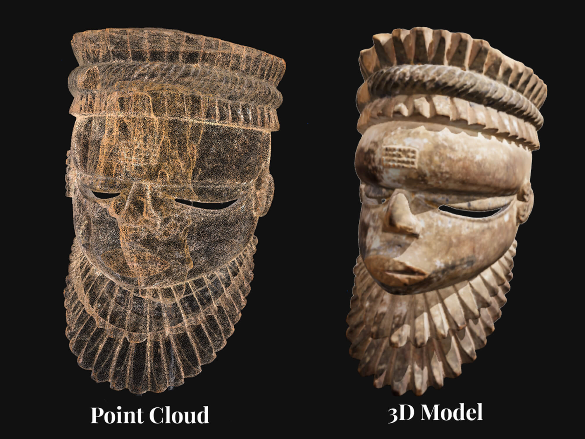
A dense point cloud (left) compared with the final textured mesh. Millions of measured points become a photorealistic surface.
Meshing and texturing
The dense point cloud is converted into a continuous polygonal mesh. Original photographs are then projected onto the mesh to create a photorealistic textured model. The result can be exported in formats suitable for web viewers, AR experiences, 3D printing, or archival use.
Common software options include:
- Agisoft Metashape — industry standard for heritage and scientific work, strong accuracy and metadata support
- RealityCapture — fast processing, well-suited for large datasets and drone captures
- Meshroom — open-source and free, built on the AliceVision pipeline, a solid starting point for institutions with limited budget
Why Photogrammetry Is Especially Valuable for Cultural Heritage
Photogrammetry excels in heritage contexts for several reasons. It is non-contact and non-invasive, making it safe for fragile or sensitive objects. The process captures fine surface details, colors, and textures that convey both authenticity and condition. When control points or scale references are used, models achieve strong metric accuracy. A single well-planned capture session can produce multiple useful outputs including 3D models, orthophotos, and scaled drawings. Digital models also create permanent records that survive physical threats to the original artifacts.
Key Applications in Cultural Heritage
Museums and heritage organizations use photogrammetry across a wide range of projects.
- Digitizing artifacts such as statues, pottery, and tools for virtual catalogs and detailed study
- Documenting monuments, buildings, and archaeological sites for monitoring, restoration planning, and change detection over time
- Drone-based mapping of larger sites and landscapes
- Creating tactile 3D prints and multisensory experiences for visitors with visual impairments
- Interactive web and AR models that allow global audiences to explore collections remotely
- Condition tracking and conservation planning
- Digital backups for disaster preparedness and recovery
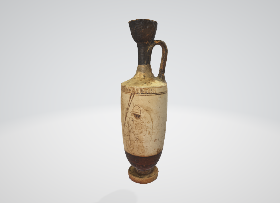
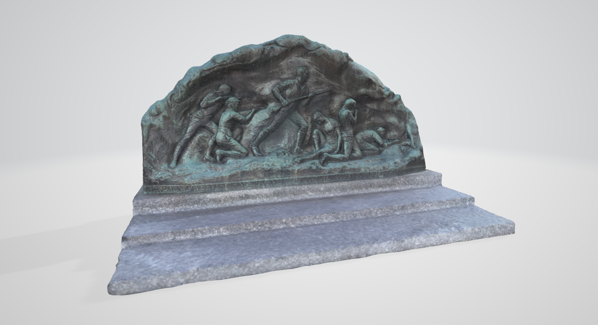
Textured 3D model of a ceramic urn, ready for web viewing, research, or 3D printing.
Exterior monument documentation using ground-based photogrammetry. The same workflow scales from small artifacts to full structures.
Benefits for Museums and Heritage Organizations
- Cost-effective and relatively fast for many projects compared with traditional documentation methods
- High visual and geometric fidelity that supports both scientific analysis and compelling public interpretation
- Digital models enable remote collaboration and broader access without moving fragile originals
- Assets can be reused across conservation, education, exhibitions, and digital outreach
- Aligns well with grant-funded work and modern inclusive exhibition practices
Challenges and Limitations
Successful projects require careful planning and good access to capture all surfaces with sufficient overlap. Results can be affected by challenging lighting, shadows, highly reflective surfaces, or occlusions. Large datasets demand substantial computing resources and storage. Final accuracy depends on image quality and proper use of control references.
Ethical considerations also apply, including community consent for culturally sensitive items, data ownership, and long-term digital stewardship.
Best Practices for Successful Projects
- Define clear goals and required outputs at the start, including accuracy level, file formats, and intended uses.
- Prepare the subject and environment with consistent lighting and systematic capture protocols.
- Implement quality control checkpoints during processing.
- Choose export formats matched to the end use, such as glTF or USDZ for web and AR, or higher-resolution files for archival and printing needs.
- Document metadata thoroughly, including capture details and processing parameters.
- Consider hybrid approaches that combine photogrammetry with other capture methods for challenging surfaces.
Real-World Examples
Institutions have successfully applied photogrammetry to digitize museum collections for condition documentation and virtual access. Large-scale projects have documented historic monuments, city centers, and archaeological landscapes. Teams have produced 3D-printed replicas from photogrammetry data for tactile education programs and handling collections. The technology has also supported conservation planning at significant heritage sites.
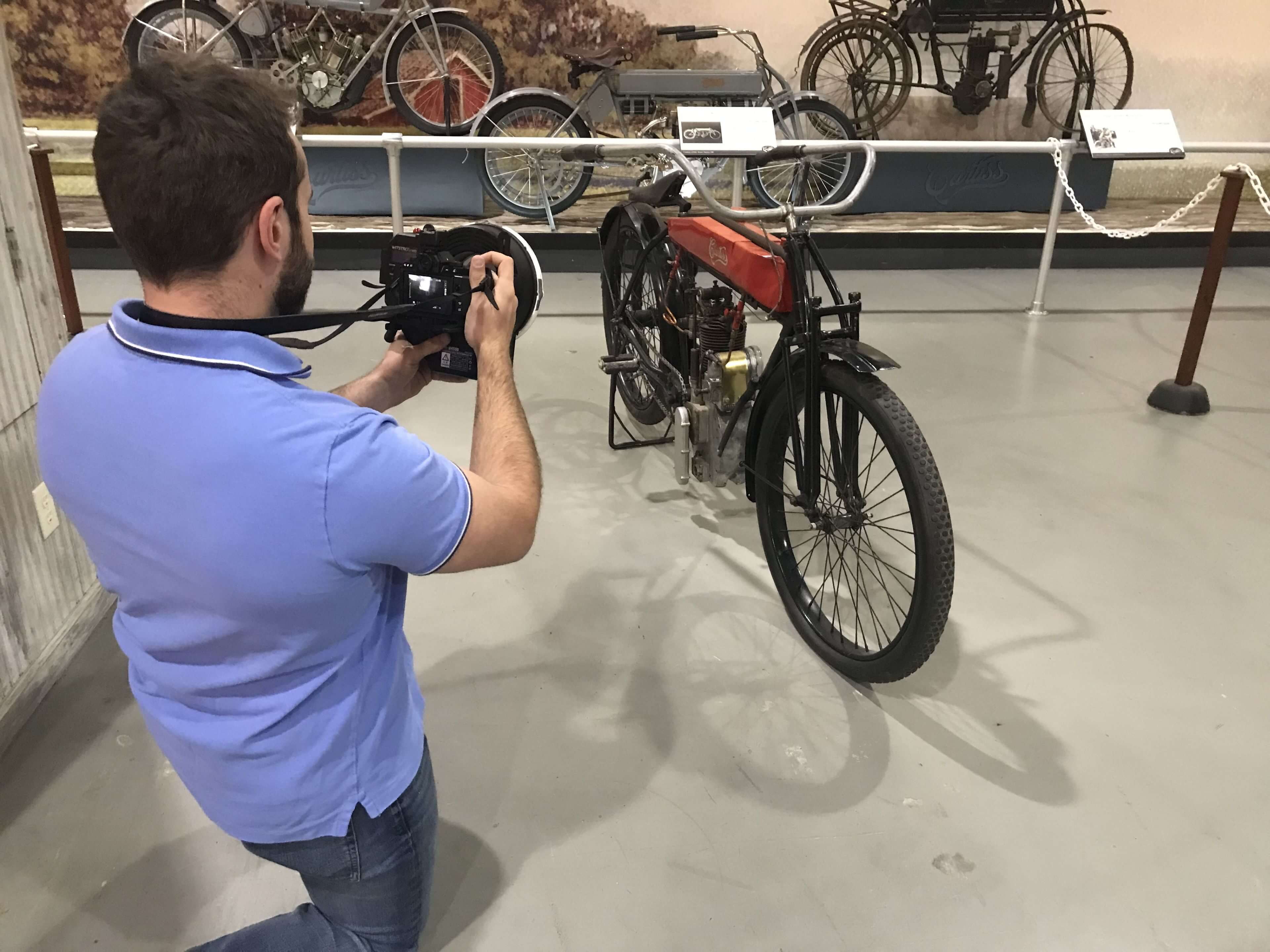
Large artifacts like historic vehicles benefit from photogrammetry's ability to capture fine surface detail and accurate geometry in a single session.
Conclusion
Photogrammetry provides museums and heritage professionals with an accessible and powerful method to document, preserve, and share cultural heritage in rich three-dimensional detail. The resulting models support conservation, education, accessibility, and global engagement while creating lasting digital records.
Organizations can begin with focused pilot projects on priority objects or sites. Professional services and training resources are increasingly available to support implementation.
Museums and heritage sites that invest in high-quality photogrammetry capture and processing gain assets that serve multiple departments and audiences for years to come.
Ready to Document Your Collection?
We work with museums, historical societies, and heritage organizations across New England. Tell us about your collection and we will put together a plan.
Talk to Our Team

